
Urban development plans for the villages of Rastatt
A village development process
The development pressure on rural areas is increasing. Pathways to coherent development perspectives and useful management instruments are highly individual and must be found together.
The housing pressure on rural areas in the Karlsruhe technology region is increasing. After the core city of Rastatt has been the focus of active urban development in recent years, the focus is now increasingly on the development of the districts of Rastatt, which are very well connected in terms of transport and infrastructure. Around a quarter of Rastatt’s population lives in the districts. At the same time, the districts take up two-fifths of the total area. Per capita land consumption is considerably higher here than in the core city. Additionally, the population in the districts has risen continuously in recent years, meaning that the issues of sensible spatial development are becoming increasingly pressing.
The consequence of this is a number of building applications in areas of the village where there was previously no need to draw up development plans, but where Section 34 of the German Building Code (“Fitting into the immediate surroundings according to the type and extent of building use”) is no longer a sufficient control instrument, both from an urban planning perspective and in terms of overall sustainable village development. As part of the village development process, urban development objectives were drawn up for all five districts, which respond to the specific issues of each district and also establish a link to the overarching spatial objectives of the district association in relation to the core city.


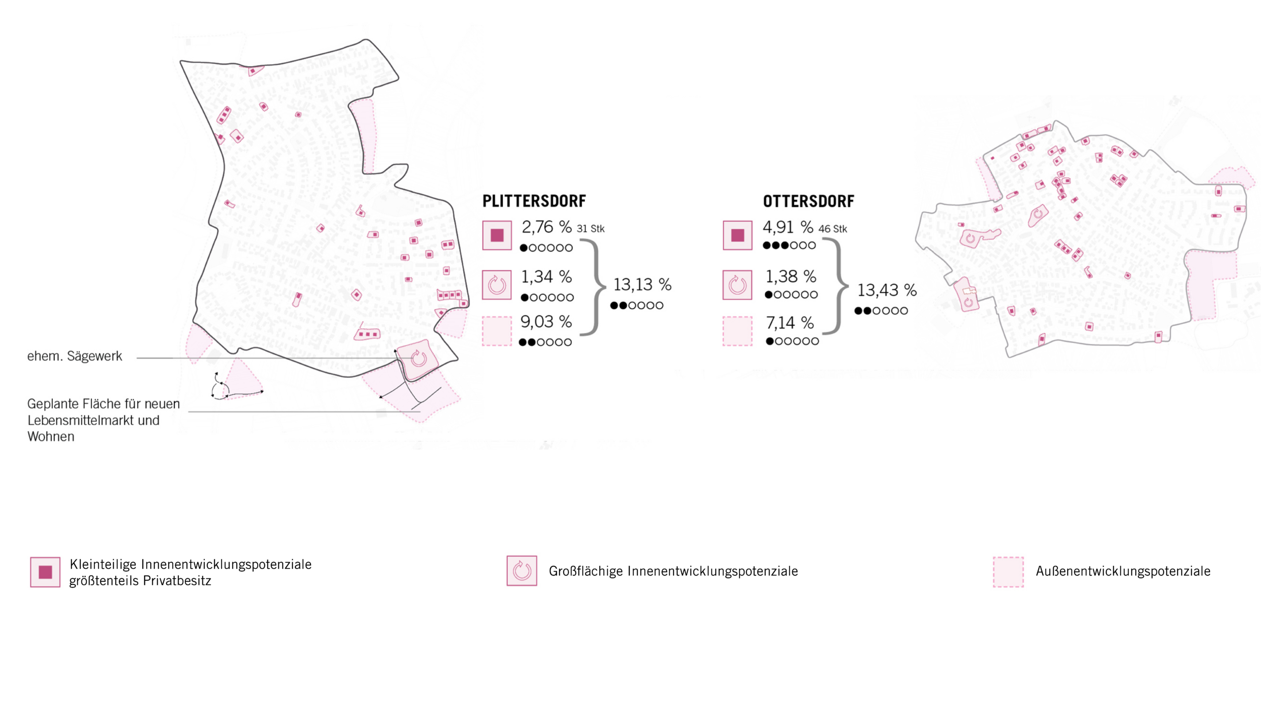
The five districts of Plittersdorf, Ottersdorf, Wintersdorf, Rauental and Niederbühl-Förch are each to be strengthened in their identity, and the promotion of the community of each district has also been a goal of urban planning since 2015. A holistic concept of urban development plans for the districts of Rastatt was created in order to identify long-term development prospects and prioritize the measures to be derived from them. A methodology was developed to analyze the current state of development of the respective settlements across the board and derive specific fields of action with future management requirements for viable and sustainable village development.
In order to initially enable a comprehensive view of each district, a physical model and detailed profiles of the individual village areas were created in close cooperation with the specialist administration and the village heads. The profiles highlight the range of topics and special features of the village areas at the appropriate scale. To complement this, an overarching target map was developed, which shows the necessary measures in four thematic areas that are applied across all parts of the village.
The target map also identifies existing and missing regulatory requirements. These are divided into three categories: framework plan, development plans and individual measures. The prioritization of the task packages identified in this way was determined in a broad discourse by the local councils and the urban planning office and approved by the municipal council.
The development concepts provide the districts of Rastatt with a common objective and a reliable planning agenda for the coming years. The proposals for measures developed and prioritized together with the local councils and the administration are individually tailored to the planning requirements and needs of each district. They form an appropriate consensus for all districts, on the basis of which the available capacities can be used in a targeted and effective manner.
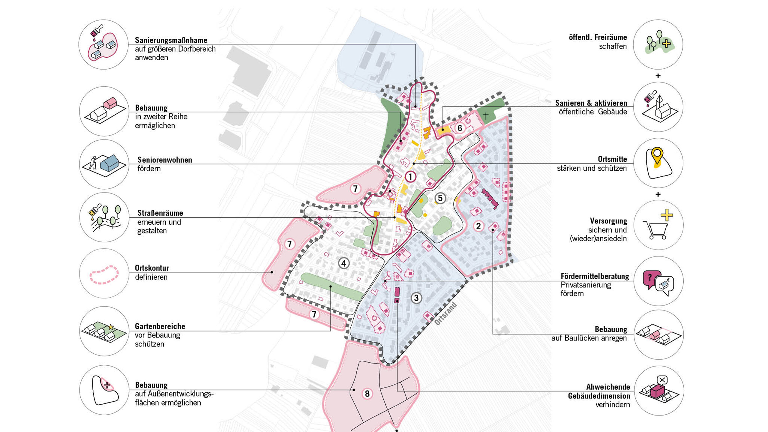
The summary brochures summarize all the findings of the analysis and the resulting urban development objectives and proposed measures for each district. The area-specific profiles are of multiple value. On the one hand, they are used by the administration as working and basic material; on the other hand, they are available to the public for information and to stimulate further discourse. In addition, they serve as a guideline for potential developers as to which developments are intended in the individual local areas from the government’s perspective and which framework conditions can be derived from this for the specific individual case.
The overall concept was adopted by the municipal council of the city of Rastatt as an “urban development concept” within the meaning of Section 1 (6) No. 11 BauGB. The contents of these brochures must therefore be taken into account in future when drawing up legally binding development plans. At the same time, they serve as a guideline for further urban development planning and as an important reference for the initial assessment of construction measures.

Client
Department of Urban and Green Planning, City of Rastatt
Size
approx. 4,000 ha
Planning
2020-2022
Service
Urban development plans, participatory process
Credits: (1–8) ASTOC
